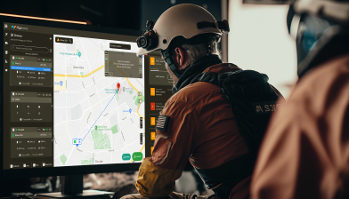
Use an automated fleet of drones to assist disaster relief and emergency response situations.
Drone Software Solution for Emergency Response
Use an automated fleet of drones to assist disaster relief and emergency response situations.
Real-time Control & Data
With cloud connectivity over 4G/LTE, gain real-time control of drones and access live data captured from the disaster site.
Intelligent Path Planning
Equip your drones to automatically navigate and carve an ideal path in disaster sites for a quick response, keeping elevation, obstacles and no-fly zones in check.
Remote Fleet Management
Manage and operate your fleet of autonomous drones in real-time, from a remote location making it ideal for emergency missions.
Artificial Intelligence
Autonomously detect anomalies, pain points and raise alarms to assist the first response teams in disaster and emergency situations.
Hurdles in Traditional Methods of Disaster Relief and Emergency Response
According to a report by the European Commission, from the years 2005 to 2014, a total of 1.7 billion people were affected by natural and man-made disasters, resulting in damages amounting to 1.4 trillion dollars. With a substantial increase in annual disasters, especially climate related ones, our disaster relief, and emergency response techniques are being tested, and it calls for an improvement.
Emergency response can constitute a lot of important missions other than natural disasters, including the like of missing persons, fire, possible suicide, crowd safety, bomb threats, fuel and/or chemical spillages, fishing vessels adrift, animal rescue, and light aircraft crashes. The importance now being specified, we look closely at why these techniques, need to be leveled up.
Time & Logistics
Time is the most important factor in disaster relief management. The quicker you are the more lives you save. However, the factor of time is very much dependent on the availability of resources to allocate, which according to traditional methods is a persistent issue with lesser developed countries, and even if you have the resources, the logistics will be a hurdle and it might take months to fully recover.
Inaccessible Areas
Say for cases of wildfires or nuclear radiation sites, is it not humanly possible to control the damage quickly, without getting up close or into the affected areas. So for actually to save lives and limit the destruction of property, emergency response and relief missions could end up taking more time, resulting in greater damages and affect a greater population.
Safety of First Responders
First responders often step into an emergency situation with less to no knowledge of the damage and its causes, which might pose as a threat to them, before anything else. First responders are ideally required to act quick according to a rough action plan based on the limited information they know, in rough and dangerous working conditions.
Slow Data acquisition and Analysis
An aerial view from above is important for disaster relief and emergency responses as it literally gives an overall picture and the extent of the affected area. Traditionally, satellite imagery has played a pivotal role in relief operations, and alternatively manned aircraft missions. But these methods mainly present two limitations, cost and the time needed to acquire images and data.
Hurdles in Traditional Methods of Disaster Relief and Emergency Response
According to a report by the European Commission, from the years 2005 to 2014, a total of 1.7 billion people were affected by natural and man-made disasters, resulting in damages amounting to 1.4 trillion dollars. With a substantial increase in annual disasters, especially climate related ones, our disaster relief, and emergency response techniques are being tested, and it calls for an improvement.
Emergency response can constitute a lot of important missions other than natural disasters, including the like of missing persons, fire, possible suicide, crowd safety, bomb threats, fuel and/or chemical spillages, fishing vessels adrift, animal rescue, and light aircraft crashes. The importance now being specified, we look closely at why these techniques, need to be leveled up.
Faster and Safer Emergency Response Approach with Drones
Drones technology is not yet at a level to replace human emergency response systems completely, but it is at a position to complement existing systems greatly to accomplish tasks faster, more efficiently, at a lower cost, and in many cases more safely than traditional methods.
Using drones for short range emergency response and disaster relief can prove to be greatly beneficial as drones can autonomously do tasks like survey of damages, locating missing people, relaying cellular networks, reaching remote areas inaccessible through land and water, and also delivering emergency supplies. According to traditional methods, all of these tasks, some even dangerous are performed by humans, consuming crucial and far more resources.
Time efficiency
Drones are fast, and aerial travel is faster, especially in disaster situations like nuclear radiation, floods, landslides, where unmanned autonomous drones can get to quickly, assess the situation and relay the live data back to base station reducing response time in a cheaper and efficient manner, thus saving more lives.
Wider Accessibility
Drone operations can be extremely useful, disaster situations like nuclear radiation, floods, landslides, where human land transport is either blocked or dangerous. Using drones with a wide aerial view to assess the situation will replace manned aircraft missions, and with drones being small enough with hover capabilities, they can get much closer to the affected area.
Assist First Responders
Essentially, drones will complement rescue and first responder missions, by getting to the disaster site first and acquire important data, assisting the planning of first responder and making them aware of dangers the wouldn’t know otherwise. A well thought of action plan with necessary information can go a long way in saving lives and preventing further damage to property.
Accurate Data Acquisition & Analysis
With drones being small, robust and equipped with various cameras and equipment, they can get very close to affected areas, and capture accurate data, essential to analyse the potential dangers and the extent of destruction. Through wireless connectivity back to the base station, the data will be transmitted quickly for analysis, aiding in a thorough robust planning.
Automate and complement your disaster relief methods for a quicker emergency response operations.
Faster and Safer Emergency Response Approach with Drones
Drones technology is not yet at a level to replace human emergency response systems completely, but it is at a position to complement existing systems greatly to accomplish tasks faster, more efficiently, at a lower cost, and in many cases more safely than traditional methods.
Using drones for short range emergency response and disaster relief can prove to be greatly beneficial as drones can autonomously do tasks like survey of damages, locating missing people, relaying cellular networks, reaching remote areas inaccessible through land and water, and also delivering emergency supplies. According to traditional methods, all of these tasks, some even dangerous are performed by humans, consuming crucial and far more resources.
Automate and complement your disaster relief methods for a quicker emergency response operations.

Go Full Autonomous with Drone-in-a-Box Solution
Integrate with Docking Stations or Charging Pads.
FlytBase provides precision landing and cloud connectivity software solutions to fully automate your drone operations using Drone-in-a-Box hardware. Subject Matter Experts (SMEs) can see the live status of the fleet, analyze real-time video feed from the drone cameras, access device status, battery and charging data, and make use of advanced drone battery features.
Go Full Autonomous with Drone-in-a-Box Solution

FlytBase provides precision landing and cloud connectivity software solutions to fully automate your drone operations using Drone-in-a-Box hardware. Subject Matter Experts (SMEs) can see the live status of the fleet, analyze real-time video feed from the drone cameras, access device status, battery and charging data, and make use of advanced drone battery features.
Integrate with Your Computer Aided Dispatch Software

FlytBase provides a software solution and support to integrate automated fleet of drones with Computer Aided Dispatch software. Get customized dashboards, remote connectivity over 4G/5G, integration with UTM, intelligent path planning, obstacle avoidance and much more as per your requirement and workflow.
Remote Drone Operations Simplified
Overseeing and controlling drone operations from a remote location has never been easier. FlytNow is a cloud-based turnkey solution, enabling deployment in a few clicks, allowing you to manage everything, on a single web-based dashboard, for a seamless experience.

Remote Drone Operations Simplified

Overseeing and controlling drone operations from a remote location has never been easier. FlytNow is a cloud-based turnkey solution, enabling deployment in a few clicks, allowing you to manage everything, on a single web-based dashboard, for a seamless experience.
Contact Us
Quick Turnkey Solutions
Get turnkey drone software POC or complete solutions customized for your requirements.
or
Talk to our drone expert.
Contact Us
Quick Turnkey Solutions
Get turnkey drone software POC or complete solutions customized for your requirements.
or
Talk to our drone expert.