-min.avif)


Get Your Free Drone Autonomy Guide Today!
In the world of autonomous drone operations, altitude isn’t just a number on your screen, it’s a critical decision that affects safety, efficiency, and mission success. Whether you're flying over rugged terrain, navigating urban rooftops, or patrolling industrial sites, one challenge remains constant: How do you ensure your drone maintains the optimal altitude throughout its flight? Which is why we’re excited to introduce Task Altitude, a powerful new feature in FlytBase’s mission planning toolkit that gives drone operators unprecedented control over horizontal cruising altitude. Designed for professionals who demand precision, Task Altitude allows you to configure the exact height your drone should maintain between takeoff and destination, even across complex landscapes.
If you're searching for advanced drone mission planning software, better drone altitude control, or smarter terrain-following drone capabilities, this feature update is for you.
What is Task Altitude?
Task Altitude is the altitude your drone maintains during horizontal travel from its current position to a destination waypoint. It acts as a cruising altitude, distinct from the drone’s Safe Takeoff Altitude or final Waypoint Altitude.
This feature gives drone operators the ability to:
- Avoid mid-flight altitude dips that could lead to collisions or inefficiencies
- Maintain a safe and consistent height over variable terrain or obstacles
- Customize altitude paths without compromising speed, safety, or data accuracy
In simpler terms: Task Altitude is the missing piece in most UAV flight planning tools, giving you intelligent altitude control between points A and B.
Why Traditional Flight Planning Falls Short
Most drone operators rely on basic altitude settings: Safe Takeoff Altitude (the initial height after launch) and Waypoint Altitude (the final height at the destination). But what about everything in between?
In real-world environments, this “start and end only” approach often creates critical problems:
- Altitude Dips in the middle of a mission increase the risk of collision with buildings, cranes, trees, or terrain.
- Inefficient Detours waste time and battery life as drones take unnecessarily cautious routes.
- Limited Flexibility prevents in-flight altitude changes based on real-time conditions.
This becomes especially dangerous in:
- Industrial zones with vertical structures
- Open-pit mines with elevation changes
- Urban areas with inconsistent building heights
- Hilly farms or forests with uneven terrain
That’s where Task Altitude comes in, giving operators control over the entire flight path, not just the beginning and end.
How Task Altitude Works
Task Altitude bridges the gap between takeoff and destination by allowing you to define the altitude your drone should maintain during horizontal flight. It works alongside two familiar parameters, Safe Takeoff Altitude and Waypoint Altitude, to create a fully optimized 3D flight path.
Here's how it behaves:
- If Task Altitude is higher than both the takeoff and destination altitudes: The drone will ascend to the task altitude, cruise horizontally, and then descend vertically to reach the destination.
- If Task Altitude is lower than both the takeoff and destination altitudes: The drone will fly diagonally from its current position to the waypoint, optimizing speed and efficiency.
- If one altitude is higher and the other is lower: The drone adjusts intelligently, using Task Altitude when it enhances safety or operational consistency.
.avif)
Flexible Configuration:
- Set a default Task Altitude per device in the FlytBase dashboard.
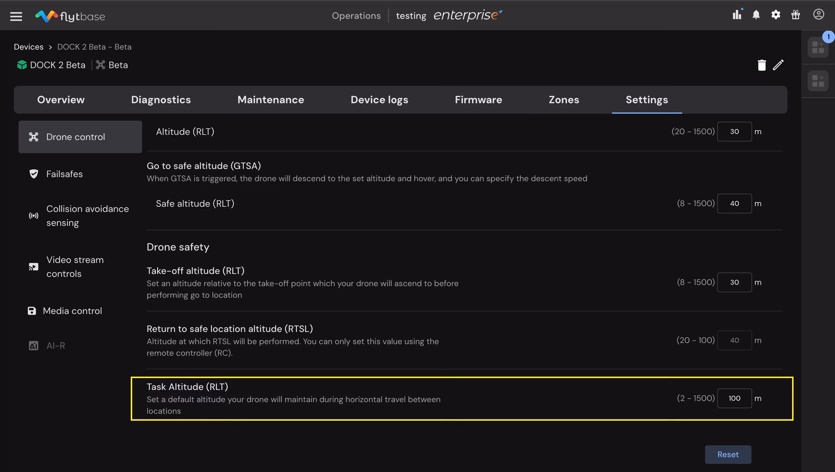
- Alter the altitude value as per the required mission within the Go To Location planning interface.
.avif)
- Modify it mid-flight without stopping or restarting the operation, which will be applied to the next subsequent GTL mission command.
FlytBase also provides real-time terrain visualization, displaying Task Altitude as a distinct horizontal line within the terrain profile. It includes visual alerts when the defined path approaches too close to terrain or obstacles, enabling better decision-making.
Where It Matters Most: Industries & Use Cases
Ready to Take Control of Your Altitude?
With Task Altitude, drone operators no longer have to compromise between safety and efficiency. Whether you're navigating around industrial assets, flying over rugged terrain, or conducting precise inspections, this feature gives you the confidence to define your flight path with clarity and control.
Built for real-world missions and trusted by enterprises across oil & gas, mining, construction, and critical infrastructure—Task Altitude is now available in your FlytBase dashboard.
Book a live demo: flytbase.com/contact
Read through FlytBase Documentation: docs.flytbase.com
FAQs
Find quick answers to common questions about compatibility, setup, features, and pricing
.webp)
.svg)
.webp)

.png)
